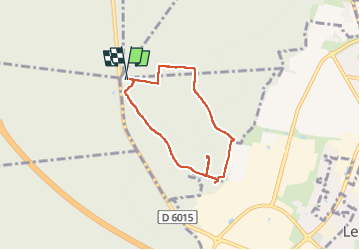
20230515-Foret de bord

doudet
User

Length
5.4 km

Max alt
141 m

Uphill gradient
110 m
Km-Effort
6.9 km

Min alt
57 m

Downhill gradient
110 m
Boucle
Yes
Creation date :
2023-05-16 07:25:03.17
Updated on :
2023-05-16 11:06:17.812
1h44
Difficulty : Easy

FREE GPS app for hiking
 SityTrail
IGN / Geographical institutes
SityTrail Plus
The world is yours!
About
Trail Walking of 5.4 km to be discovered at Normandy, Eure, Le Vaudreuil. This trail is proposed by doudet.
Description
Boucle A-R au départ du Ront Royal
Positioning
Country:
France
Region :
Normandy
Department/Province :
Eure
Municipality :
Le Vaudreuil
Location:
Unknown
Start:(Dec)
Start:(UTM)
366197 ; 5459337 (31U) N.
Comments